One of the biggest thrills in my police career was going up in a county sheriff’s office chopper to record aerial imagery of a traffic fatality down below. I was assisting one of our department’s traffic homicide investigators (THI, later redesignated as TFI for traffic fatality investigators…since most crash-related deaths are “accidents”) in his efforts to chronicle every spec and detail to expertly formulate cause-and-effect pertaining to tragic vehicular-based carnage.
I remember thinking If the public only knew to what lengths cops go to ensure facts are assessed and chronicled to critically formulate conclusive reports.
Frankly, the fuel costs of that chopper exploration, eliciting two sworn on-the-clock deputies consisting of a pilot and co-pilot, and the omnipresence of aviation catastrophe for all on board is extreme and certainly weighs heavily.
Optionally (and more cost effective) is the old-school version: cop(s) entering upon highways and byways to try to piece together cause and effect analyses. Naturally, that poses significant risk to the police personnel out there trying to gather details while also mindfully dodging automobiles. (If folks still have trouble with Move Over laws stipulating safe spacing when observing police cars and other emergency vehicles, uniformed pedestrians working a crash scene are mere specs and far slower to safely move out of the trajectory of a moving 2000-plus-pound vehicle.)
Police cohort Dan Pedersen recently touched upon the subject of officer- and scene-safety in his daily thought-provoking nuggets of wisdom published on his Living With Confidence blog: “When I was a police officer I was taught that officer safety is essential to public safety. In other words, if you respond to an incident with reckless abandon you might end up dead or seriously injured. Then you’d be no good to the people you’re there to help. To be of service to others we needed to take care of ourselves, but we’re excused from making the ultimate sacrifice. If need be, it was our job to put ourselves in harm’s way to save people from the threat of imminent death or grievous bodily harm.”
He’s right. And I recall that early-stage police academy indoctrination as if it were one hour ago. The ABCs of policing never wane, but they are enhanced by technological marvels.
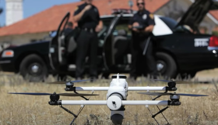
Nowadays, non-organic police partners aid us tremendously on the job…and the advent of drones assumes much of the safety factors in police work.
Drones are much more affordable, compact carry-alls (police car trunk), pose zero danger to operators and motorists/pedestrians in the area, use no fuel, allow roadways to not be shut down or funneled (motorist disgruntlement and concomitant aggressiveness/recklessness/secondary incidents), provide excellent resolution in their recording qualities, and allow as many repeat visits to the crash site as deemed necessary by a sole investigator/operator and, where deemed useful, a secondary officer known as a “spotter” or “visual observer” (VO).
Drones are just one example of AI (artificial intelligence) aiding and safeguarding humans, and more law enforcement agencies are taking advantage of the safe, affordable, unencumbered novelty.
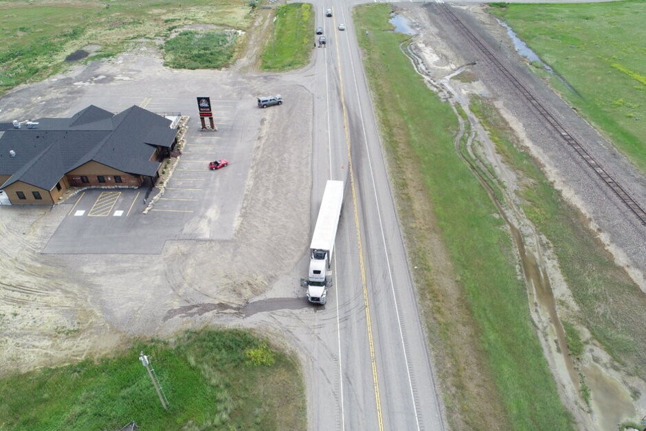
A case study in Montana examined the use of drones by Montana Highway Patrol (MHP) troopers who specialize in traffic crash investigations and reconstruction events…without having to board a police chopper or walk out in the roadway where the carnage occurred and dangers persist.
Writing for Government Technology, Jed Pressgrove chronicled Montana state troopers’ use of drones and photogrammetry software since 2018, assessing pros/cons of investigators’ findings stemming from compact technology and effectiveness at (over) traffic crash scenes.
As expected, law enforcement officers found the cereal-box size technology “dramatically increased efficiency, safety and accuracy,” making it a win-win for investigators and motorists alike.
“Shawn Hazelton, a sergeant with the Montana Highway Patrol, remembers more than 20 years ago when his agency didn’t even use a total station, an electronic surveying device, to map out a crash scene. Officers would spend hours measuring lines with manual tools [by hand]. Not only would they
Come away with limited data, they had to watch out for traffic as they walked back and forth across a road,” Mr. Pressgrove reported.
Indeed, I know of no cop who enjoys playing chicken with unknown individuals operating automobiles at speeds often beyond the posted limit. Yet, before drones, this was largely the case. Along with squad-mates, I’ve had my fair share of formal calculus while dodging whizzing projectiles captained by people who seem to turn a blind eye to red/blue flashing lights.
As Sergeant Hazelton highlighted, “You would hope people would pay attention and slow down for your lights.” That is a hope shared by every LEO in the nation. Ironically, the motorists paying attention part, if done empirically and consistently, would basically preclude the need for that hope. But no such luck: smash-up derby persists, and cops will be out there blueprinting the tragic turn of events with handy-dandy drones.
What used to take several boots-on-the-ground LEOs armed with basic writing instruments to jot down particulars while mindfully endangered with traffic potential flow is a thing of the past.
A traffic homicide investigator with MHP, Trooper Aaron Freivalds said, with the advent of drones, “I can go out by myself and process a quarter-mile scene in 30 minutes without interfering with the flow of traffic, without having to walk in the roadway at all, and then take those photographs back to my office and finish processing the scene remotely.” Voila!
Trooper Freivalds makes it sound easy…because it is. A growing body of evidence is mounting among law enforcement organizations buying into drone technology and its applications in modern-day policing.
How does it all come together with drones? To replicate the crash scene, hundreds of photos are recorded by the roving/hovering drone. These images are then transferred to the photogrammetry software we mentioned earlier. That software processes the photo-stills and delivers three-dimensional illustrations of the incident scene.
Per Montana Highway Patrol Trooper Philip Smart, “A jury can really experience what the scene was like.” And his point is quite valid. Before drones, cops did their darndest to illustrate a crash site by literally hand-drawing a basic image and/or showing photo stills taken while playing that game of chicken, accompanied by perhaps not so easily digestible jargon explaining traffic crash nuances.
As is understandably the case with our species, humans love and appreciate stories when accompanied by resolute cinematography, and drones can offer that as well. Thus, this technology weighs in with courtroom litigation and empaneled folks responsible for deciding liability, having a comprehensive fact-based simulation of cause-and-effect incidents.
As the Montana Highway Patrol drone study illustrates, we’ve come a long way!
And that same progressive technology used in traffic reconstruction lends well to other pertinent police work.
When in the police academy for basic training many years ago, we were taught how to detect/collect evidence at large-scale crime scenes by using what was called the “line search,” the goal of which was to gather a line of police officers and slowly walk a crime scene for bits and pieces of evidence. That meant lots of cops each individually covering a portion as part of a collective to sift through a massive tract of landscape—that method was time- and staff-consuming. With drones, one cop (operator) can do all that with minimal effort as long as necessary (while all others handle calls on behalf of citizens calling for service).
Upon retirement from law enforcement, many seasoned traffic fatality investigators assume roles with insurance companies, essentially reasoning fault/liability so that agents and underwriters can judiciously mitigate/litigate on behalf of their policyholders. Given their affordability, safety features, and effectiveness in detailing crash dynamics, there is plenty reason for insurance entities to also employ drones operated by former police personnel highly trained in their use and FAA-licensed
to deploy these relatively silent flying film studios.
Similarly, drones can also detect oddities, differentiations, and distinctions aerially, pertinent things which boots on the ground may not readily discern due to same-level acuity (lack thereof).
I believe it was in Iowa, one example whereby drones were used for a search-and-rescue (SAR) operation in which a “missing person” who was reportedly endangered due to dementia wandered away from home. That senior citizen was located laying down in the midst of a robustly-grown corn field, thanks to aerial views provided by a police-operated drone.
A multiple-homicide case which transpired in Central Florida a handful of years ago had hundreds of LEOs walking hundreds of acres of pasture owned by the prime suspect. As part of their investigation, cops believed that land may contain bits and pieces of buried evidence. The media outlets covered the story and, via news station choppers, depicted the enormous “line search” conducted by a great number of uniformed police personnel—clearly pre-drone era.
Like an on-duty lifeguard at his/her elevated beach post, discerning things out of whack can more easily be judged from an aerial latitude than ground-level viewership. For those cops in the above-referenced line search of pastureland, a drone would have detected soil disturbances to denote something recently buried (potential grave site).
Drones have integral use in police work, especially when it boils down to officer and citizen safety. Akin to police canines deployed to sniff out bad actors as human counterparts gear up for an apprehension with paramount safety, drones can be used to survey scenes and ensure police strategies and tactics are well considered before volatile situations are countered.
In the following video we see extraordinary craftmanship and engineering marvels in five different models of drones and their field use by military, police, and any manner of industry whereby harsh conditions, varying climates, underwater world, or unforgiving terrain are navigated safely, effectively, and successfully:
In the video’s second scenario, my old-school-police-era mind never would have imagined police departments having UAV (unmanned aerial vehicle) dedicated units to combat crime and enable the police mission with compact remote devices.
Of the growing body of police agencies adopting drones as part of their fleet to complement service delivery, the Splendora, Texas Police department has some in-depth exploration for us.
Splendora police Officer Alex Hadrych comprehensively articulates his agency’s drone implementation (at 5:08) “to better serve our citizens in times of need or a natural disaster,” emphasizing how he “can’t see performing some of the mission-critical roles that we do play now without this technology” while also citing that police agencies are starting to realize they “couldn’t live without this” drone equipment fashioned to advance police work and exceed citizens’ safety.
Eye in the sky for situational awareness and officer safety, serving the public with space-age technology? Indeed, so police operations take off without a hitch or sacrifice of a public-serving heartbeat.